 |
| New Mexico mountain top, 2012. The clouds did stay on one side of the mountain range. |
Before all else, American and Mexican deserts that are not immediately east of a mountain range became deserts, due to the "North Pacific High." This happens to be a semi-permanent, subtropical, high pressure air mass that rotates clockwise. Its altitude reaches up to the middle of the Troposphere only. It's latitude is equal to that of Northern California and Oregon. Yet, it's a large rotating air mass.
Also needed to be mentioned is that the 30th Parallel, in the northern and southern hemispheres each have a convection cell which features dry, relatively-heavy, & sinking air. This is why major deserts are on or near the 30th Latitude. Incidentally, sinking air is called "subsiding' in meteorology.
Then comes deserts featured by "Santa Ana Winds," aka "Chinook Winds," aka "Foehn Winds." All three winds are the exact same thing. Let us proceed.
~ ~ ~ ~ ~
a} That which is called the result of "global warming" is actually the result of Adiabatic Heating which occurs on the the Leeward Side of mountain ranges; mostly the east side.
This is because, as clouds rise upon the Western side (aka the Windward Side) of a mountain range, they release moisture during the ascent. This is known as the process of Orographic Lifting.
This lifting of a cloud mass accompanies the
release of rain as the clouds' ascent continues. By the time the same
air mass reaches the top, all that is left is a cold & dry parcel of
air which descends the mountain range, thereby creating deserts.
There is the matter of heating which occurs during the air parcel's
descent. The heating is due to descending air becoming compressed.
b}
The dry air parcels which descend mountain tops are called ::: ~Foehn
Winds, ~Chinook Winds, ~Santa Ana Winds, & ~Down-sloping Winds.
As a dry air parcel descends a mountain top, it encounters higher &
heavier pressured air which easily exists at the surface of the Earth.
As a result, the down-sloping air compresses and shrinks in size. This
causes the molecules within it to collide and vibrate more aggressively,
resulting in a sudden rise in temperature.
c1a} Proof that this dryness is the result of Adiabatic Warming, and NOT co2, exists in the fact that, when you are out West, you notice that the clouds in the sky never cross over the mountain tops. The clouds stay on one side.
c1b} Incidentally, I'm the son of a native Wyoming gal. In fact, I have literally been at the southernmost tip of the Rocky Mountains, in New Mexico. I witnessed it. I was there.
 |
| Yes, this was the city of the Project Y laboratory; part of the Manhattan Project. |
 |
| New Mexico, as scene through my cell phone; from a road to Los Alamos. |
 |
| Also New Mexico from my cell phone. Notice that the clouds remain on one side. |
 |
| This authentic mushroom cloud was photographed on an August 6, near Los Alamos. |
c2} Examples of deserts created by Adiabatic Heating ::: The Red Desert of Wyoming is in the center south of the State. Plus, the center of Oregon has a desert located east of the Cascades and south of the Blue Mountains. The Leeward Side of California is desert land extraordinaire, and it was that condition long before 21st Century co2 levels increased. Etc go the examples.
c3}
Plus, the super large deserts of the Earth are all on the 30th parallel
(north & south) wherever the desert was not the result of Leeward
Adiabatic Warming. 30th Parallel deserts were caused by very large
"convection cells."
Example ===> The Sahara Desert is the size of the USA, and 6,000 years ago the Sahara was a lush forest/jungle, with cave wall drawings that looked like the ones in France. This time span is known as the African Humid Period. There were no gasoline engines to turn the Sahara into a desert. It was a major convection cell at the 30th Parallel that caused it. The super large convection cell still exists. It's presently called the Hadley Cell of the Northern Hemisphere.
When viewing Globes or spherical maps of the Earth, do not forget the 23.5 degree tilt (aka obliquity) of Planet Earth.
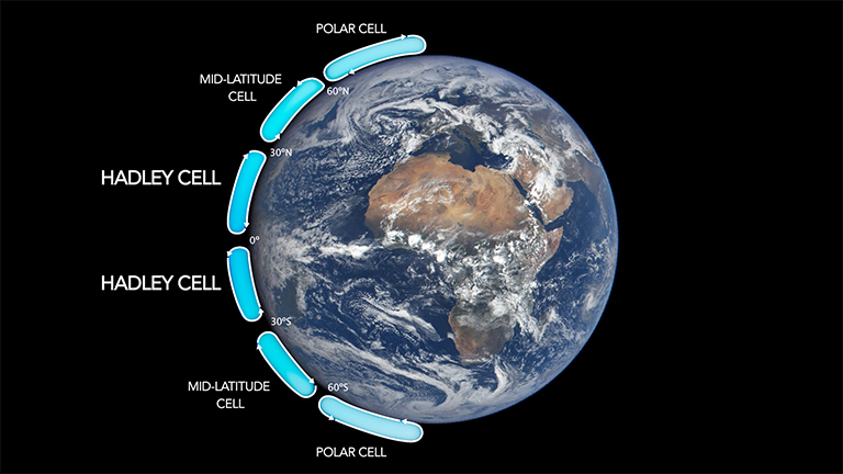 |
| Take note: In older textbooks, "Mid-Latitude Cells" were called "Ferrel Cells." |